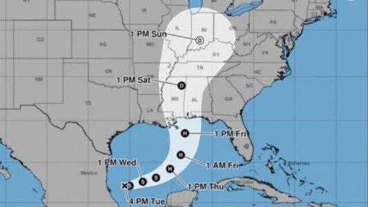

The system could become the first hurricane of the 2026 Atlantic hurricane season, forecasters warn. Tropical Depression Nine has formed in the western Gulf of Mexico and is expected to strengthen into Tropical Storm Isaias. If the system’s winds reach at least 39 mph it could become Tropical Storm Isaias, the National Hurricane Center said. It is forecast to strengthen into a hurricane by late in the week before potentially approaching the Gulf Coast.
The storm could bring heavy rain and gusty winds from Louisiana to Florida, with impacts potentially extending from Texas to Florida. Residents from Louisiana to the Florida Panhandle have been urged to closely monitor the storm and have a hurricane plan in place.
Isaias Tracker Path: Where Could The Storm Go?
Tropical Depression Nine is expected to drift east for a time before turning north toward the Gulf Coast. Forecast models show a possible track ranging from Louisiana to the Florida Panhandle by late Friday or early Saturday.
After landfall, the system is expected to move inland across the Southeast. Much of the storm’s impacts are likely to occur along and east of its path.
Because the system is still early in its development, forecasters say there is uncertainty over both its exact path and how quickly it will strengthen.
Tropical Storm Isaias Forecast: How Strong Could It Get?
The system is expected to move over Gulf waters with temperatures well into the 80s, providing conditions that could support strengthening.
However, wind shear could limit its development. Stronger and more persistent wind shear would likely keep the storm weaker, while less wind shear could allow Isaias to become stronger and potentially reach hurricane strength.
The wind shear is expected to increase farther north, meaning the storm could lose some intensity as it approaches land.
The current most likely intensity near landfall is a Category 1 or Category 2 hurricane.
Gulf Coast Rain And Flooding Threat
The exact impacts will depend on the storm’s track, speed and strength.
Heavy rainfall could reach the Gulf Coast as early as Friday before spreading inland through the weekend. Some areas could receive as much as 10 inches of rain, while most locations could see between 3 and 6 inches.
Heavy rain and potential flash flooding are possible near the storm’s landfall. Flooding rainfall could also extend across much of the Southeast, the Appalachians and possibly parts of the Ohio Valley and mid-Atlantic.
Storm surge flooding, strong winds and isolated tornadoes could also affect areas near the Gulf Coast before and after landfall.